CIRI Calculator
logout
Web-Based GIS tool for the Community Intrinsic Resilience Index*
*Preliminary Data Disclaimer: Data and Results reported on this site are to be used for educational purposes only. Results are used for training purposes and are not calibrated.
Community Intrinsic Resilience Index
The Community Intrinsic Resilience Index (CIRI) is an absolute metric that measures the resilience level of
communities to natural disasters.
CIRI evaluates the desired community by assessing the resilience level of 4 critical sectors: Transportation,
Energy, Health and Socio-Economic.
The resilience level of each sector is computed using different attributes that were found to play a
critical role in the community capacity and ability to endure and recover following disasters. These
attributes are listed below:
- Transportation
- Road Area (Population): Available road area (in square mile) per 1000 population
- Road Area (Land): Ratio of available road area to the total land area of the community (in square mile)
- Transit Performance: AllTransit™ Performance Score
- Household Vehicle: Number private vehicles per 1000 population
- Energy
- Power Distribution Network: Composite index that includes the percentage of underground wires and wires quality
- Microgrids: Number of people using electric power transmitted via micro-grids per 1000 population
- Renewable Energy: Number of people using electric power from a renewable source per 1000 population
- Health
- Hospital beds: Number of available hospital beds per 1000 population
- Practicing Physicians: Number of practicing MDs and DOs per 1000 population
- Health Insurance: Number of insured people (private, Medicare, Medicaid) per 1000 population
- Socio-Economic
- Education: Number of people having a college degree or higher per 1000 population (25 years and over)
- Creative Class: Number of people working in creative occupations per 1000 population (civilian population 16 years and over)
- StormReady: Number of people living in StormReady community per 1000 population
- Per Capita Income (PCI): Per Capita Income
- Per Capita GDP: Per Capita GDP (in chained 2012 dollars)
Computing CIRI
Each attribute is transformed into a percentage using the Perfect Score, which describes the
attribute value in a best case scenario.
Each sector resilience is the weighted average of the attributes within. An attribute weight represents
the relative importance of such attribute within the corresponding sector:
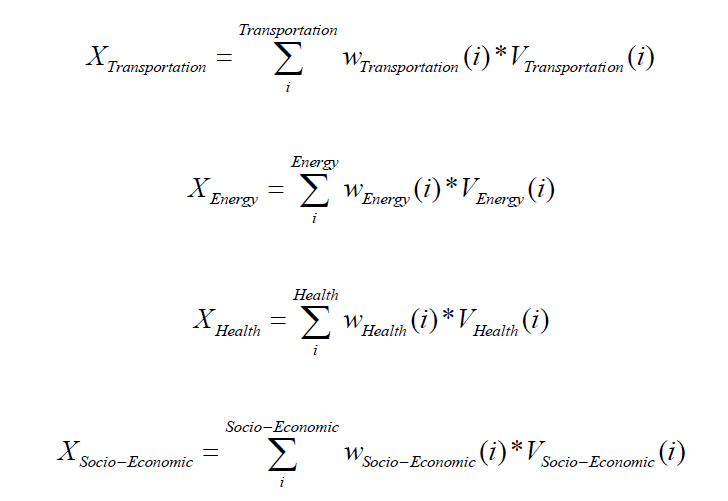
CIRI is the weighted average of the four sectors. A sector weight (α) represents the relative importance of such sector on the community resilience:

"P" in the CIRI equation, represents a penalty function, and it is computed as such:
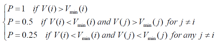
"P" reflects the fact that if an attribute value falls below a certain threshold, the whole system would be affected.
The default minimum value (%) is set to 10% for 6 critical attributes: Road Area (Population), Road Area (Land), Power Distribution Network, Hospital beds, Practicing Physicians and Per Capita GDP. Users would have the ability to change such minimum value for each attribute.
Using CIRI Calculator
To start, a user must select the location for which the CIRI is desired. To do so, 3 selection modes are available:
- Manual Selection: Sketching the desired location on the map. Not bounded by political boundaries
- County: Selecting the desired county from the map
- Municipality: Selecting the desired city/township/borough from the map
When the processing is done, information about the selected region will be shown along with CIRI and the individual sectors resilience. In addition, a table will be shown containing all the attribute details. A user can recompute the resilience level (CIRI and sectors resilience) by modifying the attribute values, the attribute weights, minimum values, and the sector weights.
Data Sources
CIRI calculators uses the following layers/GIS data:- Roads Layer: https://maps.nj.gov/arcgis/rest/services/Framework/Transportation/MapServer/0
- Census Block Groups Layer: https://services.arcgis.com/P3ePLMYs2RVChkJx/arcgis/rest/services/USA_Block_Groups/FeatureServer/0
- Counties Layer: https://maps.nj.gov/arcgis/rest/services/Framework/Government_Boundaries/MapServer/1
- Municipalities Layers: https://maps.nj.gov/arcgis/rest/services/Framework/Government_Boundaries/MapServer/2
- Annual Average Daily Traffic U.S. And NJ Routes: https://njogis-newjersey.opendata.arcgis.com/datasets/NJDOT::annual-average-daily-traffic-u-s-and-nj-routes/explore
*** For the time being, CIRI calculator is to be used for New Jersey Communities.

Start by making a selection!